
![]()
OUR VILLAGES
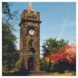
Located North East of Chorley in Lancashire at the foot of the West Pennine Moors, the two communities of Heapey and Wheelton have for generations been inexorably linked and there is no more obvious reminder of this than the Heapey and Wheelton War Memorial jointly built across the parish boundaries and completed in 1922.
Today the Parish Councils of Heapey and Wheelton work closely together on matters of mutual interest. One such project currently being undertaken is the Parish Plan. See Stop Press on the Home page for regular updates and details of how you can get involved.
So, what areas do the two parishes cover?
Heapey Parish extends from the Leeds & Liverpool Canal in the north to Anglezarke reservoir in the south and from the eastern edge of Knowley in the west to Heapey Moor in the east. It is a rural parish between the settlements of White Coppice, Wheelton and Heapey Chase.
Wheelton Parish covers the settlements of Higher Wheelton, Wheelton village (sometimes known locally as Lower Wheelton), Briars and Buckholes Brow and Logwood. The parish also extends south-east to Wheelton Plantation and Wheelton Moor.
Mail us if you have information to add to these pages of the website. We would like more information on local history, things to do and your photograph's of the area website@heapeyandwheelton.org.
SURROUNDING VILLAGES AND TOWNS
Withnell Fold conservation village & nature reserve
If you want a pleasant walk on a summers afternoon you can stroll along the canal to Withnell Fold, and take a visit to the nature reserve and Cricket Field. Withnell Fold is a peaceful little village and features original mill houses, impressive old mill chimney, Methodist Chapel, cobbled road and village square, with its medieval village stocks and original school. Near the stocks is a sunken garden, formally a lodge for the paper mill, now a memorial for the two World Wars. The village was built entirely by the Parke Family in the mid nineteenth century to house the workforce for the paper mill, the remains of which can still be seen, although much of the mill has now been demolished or converted to homes.
The nature reserve can be found over the canal bridge and beyond the towpath. This area was originally a series of filter beds for the paper mill, which stood on the eastern side of the canal. Today the site supports a wide variety of plants and wildlife and was acquired by Lancashire County Council to be managed as a Local Nature Reserve, and contains a hide to view the wildlife.
Anglezarke, Rivington Hall, Barn and Country Park
Lord Leverhulme bequeathed his beautiful Lever Park at Rivington to the people of Chorley. The park, on the slopes of Rivington Moor overlooking Chorley, comprises landscaped gardens, tree-lined avenue, barns and a Georgian hall. Ideal for a day out, there are walks through the parkland on the banks of the reservoir and the slope of Rivington Moor as well as the ramble through the abandoned gardens of Leverhulme's old bungalow destroyed by fire when it was set alight by a suffragette! It is possible to walk to the top of Rivington Pike to see the folly built there and also enjoy stunning views over Chorley, Horwich and Bolton. When you get back down, you can even get refreshments!!!
Anglezarke is part of the West Pennine Moors and can be accessed from Brinscall, White Coppice and Rivington.
There's a good website for anyone who wants to see some great images of White Coppice, Anglezarke & Rivington at http://www.white-coppice.co.uk.
Chorley
Chorley is situated on the A6 between the M6 and M61 about 10 miles to the south of Preston and to the north west of Bolton between the hills of the West Pennine moorland and the coastal plain of Southport.
The town is probably best known for its market. Chorley 's market charter dates to 1498 but experts believe the town it is older than that. There are two markets - the covered market (open Tuesday, Thursday, Friday and Saturday) and the open Flat Iron (on Tuesday only). How the Flat Iron gets its name we do not know but the variety of goods offered for sale is wide and ever changing - a reason why it is visited by people from near and far.
Brinscall
Brinscall lies in the valley at the foot of the West Pennine Moors and owes its development from a farming community as well as the cotton industry. When the cotton industry came to Lancashire in the 19th century, a thriving community of handloom weavers existed in the valley area. William Christopher Wood built the present Brinscall Hall in 1876, and a calico printworks, which employed a number of people but finally closed in 1928. The ruins of many of these buildings are now surrounded by woodland known as Wheelton Plantation. The area is now owned by North West Water Authority and is part of the Anglezarke link of reservoirs and also a nature conservation area.
Halfway up School Lane , the main street of Brinscall, is Hillside Methodist chapel, where the famous singer Kathleen Ferrier was married. The village school, St John's , was the first combined Church of England/Methodist primary school in Lancashire .
The swimming baths in Brinscall were built to celebrate the coronation of King George V, with generous donations from Withnell Fold papermill owner and benefactor Herbert J. Parke. The cottage hospital was built to celebrate the coronation of King Edward VII by the same benefactor in 1902. The village cricket field, which accommodates three thriving teams, is held in trust by the villagers, also by courtesy of the Parke family.
Astley Hall
Astley Hall is Chorley 's 'grand old house' and it is situated on a Bronze Age burial ground. The hall itself, and the well-wooded park which surrounds it, was given to the town in 1922. Initially it was a half-timbered Tudor House first built by the Charnocks and in 1666 extensions and alterations were completed. Royalist troops retreating from the Battle of Preston in 1648 fought pursuing Parliamentarians in the Chorley are and you'll even discover a pair of Oliver Cromwell's own boots at the Hall!! The hall is open to the public but it is as well to check on the opening times. There grounds, which have scenic nature trails, are open throughout the year and the lake is a haven for wildfowl. The old stable-block has been converted into a cafe and inside the hall are ornate plaster ceilings and a shovelboard, which is more than 20 feet long and supported on 10 pairs of stout wooden legs. This was a game rather like an extension of shove halfpenny but maces, which were used like snooker cues, moved huge coins.
Hoghton Tower
Hoghton Tower : a few miles outside the parish, Hoghton Tower is of significant historic importance and just a great place to visit! Over the centuries this ancient fortified manor house welcomed and entertained many distinguished guests and visitors including King James I, William III, George V and Queen Mary, the Duke of Edinburgh just to name but a few. It is said that William Shakespeare spent some time with the family (1580 - 81) and more and more documents seem to confirm it. Hoghton Tower is the ancestral home of the de Hoghton family since the Norman Conquest. The proceeds from events ranging from guided tours, concerts, recitals, opera, ballet, dinners, conferences, lectures, antique fairs and outdoor events all go to the upkeep of the tower.
People interested in buying good local produce may want to visit the monthly Farmers Market which is held on the 3 rd Sunday of the month. See the website for further details of these and other events at the Tower see www.hoghtontower.co.uk.
Leeds Liverpool Canal
The Leeds Liverpool Canal forms the boundary between Wheelton and Brindle. This corridor provides a wonderful opportunity for leisure activities. It is a popular stretch of water for fishermen. It is much used by leisure craft both based at Wheelton Boat Club and travelling through the area to Blackburn, East Lancashire and beyond. The towpath provides a great walkway suitable for families especially those with young children who enjoy feeding ducks! There a number of welcome pub stops along the route as well - but don't overdo it, parts of the path are isolated and if you fall in there could be no-one for miles to help you out.
Eagle Tower View Point
Eagle Tower View Point can be found behind St Barnabas' Church on Heapey Lane. Park on the car park just uphill from the church and from the lane down the side it is possible to see right across the West Lancashire Plain to the Fylde, Blackpool and the Irish Sea. Particularly stunning on a clear autumn evening when the Illuminations are on!! It has been suggested that the name Eagle Tower originated in Roman times when an outpost at this spot or one similar allowed the garrison there to keep watch on the main route north from the Roman settlement in Chester to the western end of Hadrian's Wall. It's possible!!
From here you can continue along a very picturesque public footpath towards Heapey Chase, and then connect to footpaths leading to White Coppice village.
Johnson's Hillock Locks
The Johnson's Hillock Locks are a flight of 7 locks, no's 58 to 64, stretching from the Whittle Springs basin to the Top Lock public house. The Top Lock attracts a good crowd of walkers and day trippers, who enjoy the real ale and range of good food (traditional pub fayre and authentic Indian dishes). Just above Whittle Springs basin is a picnic area and the spot is very popular with fishermen and families as well as boatmen.
Wheelton Plantation & the West Pennine Moors
Wheelton Plantation & the West Pennine Moors are accessible from the neighbouring village of Brinscall. A great area for walking, fell-running or just pottering. Can get muddy so wear appropriate footwear.
E-mail us if you have information to include in these pages of the website@heapeyandwheelton.org.